

CORPORATE
Progress You Can See, Solutions You Can Trust
Complete Service Provider
At Aerial, we provide comprehensive drone services for construction companies. From high-accuracy mapping to cinematic footage and site monitoring, we deliver precision, efficiency, and innovation for every stage of your project.


FULL PRODUCTION

FPV

CGI

AERIAL VIDEO

SECURITY
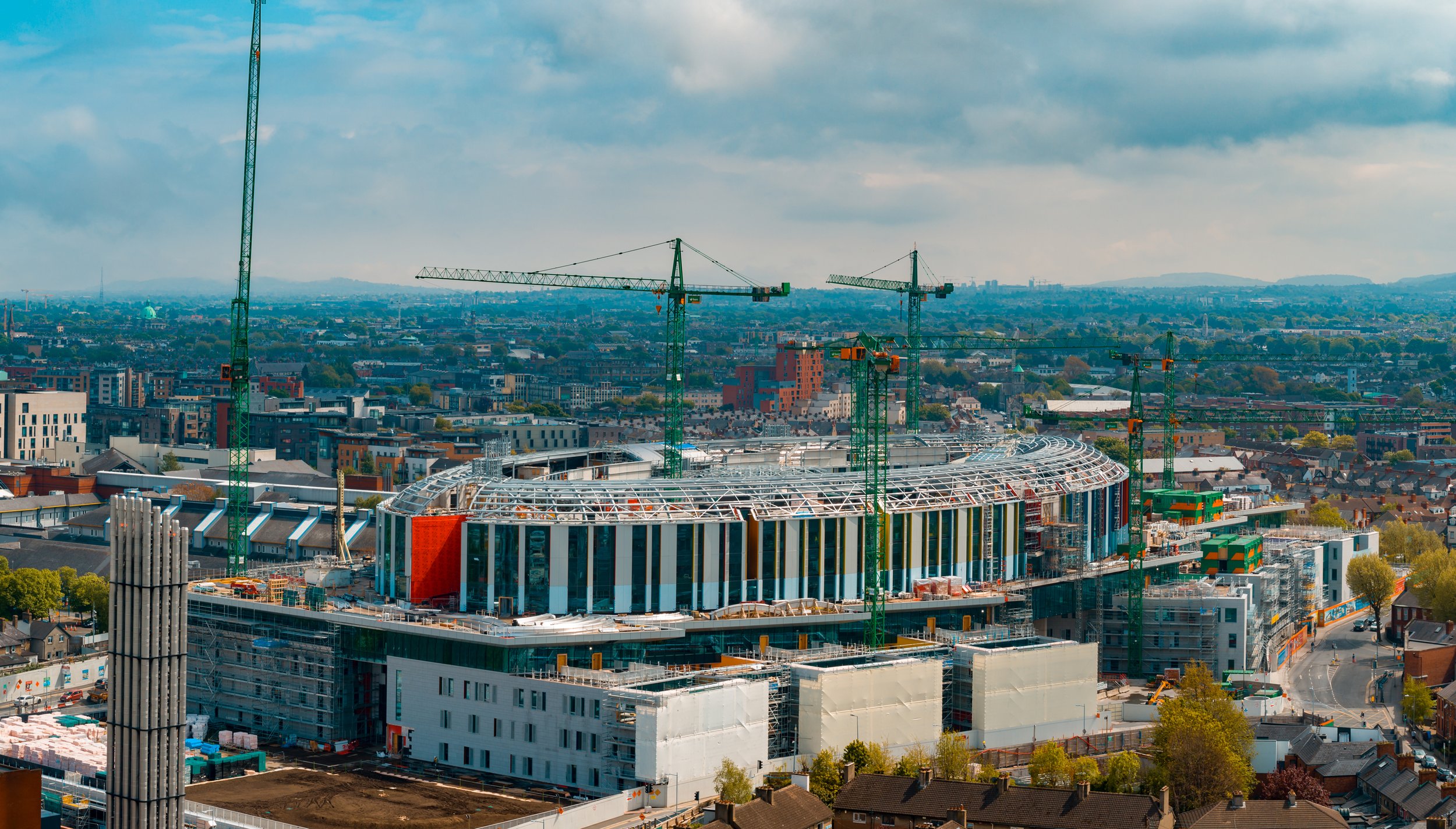
Enhanced Site Management & Efficiency
Drones provide construction managers with a fast and efficient way to oversee large sites, track progress, and identify potential issues before they become costly problems. Our aerial services offer real-time updates, high-resolution imaging, and 3D mapping, helping you make informed decisions, streamline workflows, and keep projects on schedule.
Improved Safety & Risk Reduction
Construction sites are full of hazards, and sending personnel into dangerous areas for inspections can put them at risk. Our drone surveys eliminate the need for manual checks in hard-to-reach or hazardous locations, providing a safer alternative while delivering accurate data. Minimise downtime, reduce liability, and ensure compliance with health and safety regulations.
High-Quality Marketing & Client Engagement
Showcasing your projects with stunning aerial visuals sets you apart in a competitive market. Our drone services capture high-resolution images and cinematic video, perfect for marketing, investor updates, and client presentations. Whether highlighting progress, showcasing completed builds, or creating promotional content, our aerial footage helps you tell a compelling story and attract more business.

CASE STUDY
Platt Reilly, Cairn Homes & Ekowall
Ekowall
As a trusted partner, we align our expertise with your organizational goals, delivering tailored solutions that drive measurable outcomes and long-term success.

▶︎


From Vision to Reality
Working with Aerial is a seamless and professional experience from start to finish. We handle everything from planning and compliance to data capture and final delivery, ensuring a hassle-free process for our clients. Our team prioritizes efficiency, accuracy, and safety, so you get high-quality results without disrupting your operations. Below is a step-by-step breakdown of what you can expect when partnering with us.

We begin with a discussion to understand your project’s needs, scope, and objectives. A precise flight plan is designed to capture the required data efficiently. We coordinate with your team to schedule flights at the best times for minimal disruption.
1. Consultation & Planning

2. Aerial Capture
Using advanced drone technology, we capture high-resolution imagery, videos, or survey data. Our experienced pilots ensure accuracy and safety while keeping operations quick and efficient.

3. Post Processing
Collected data is processed using industry-leading software to generate maps, reports, and marketing visuals. We refine and format the outputs to ensure they’re clear, actionable, and ready for use.

4. Delivery
Final assets are delivered in your preferred format, with explanations or insights as needed. We remain available for any follow-up questions, future updates, or additional services.


Sean Noone - Platt Reilly
"Partnering with Aerial was a great experience. They were extremely helpful, providing creative ideas and working closely with us to produce a high-quality product. Their professionalism and efficiency made the entire process seamless and stress-free. Highly recommend." -
Full Production Service
At Aerial, we provide a seamless, end-to-end production service, ensuring every project is expertly managed from concept to final delivery. Our team handles everything from planning and coordination to on-the-ground videography and dynamic aerial drone filming, capturing stunning visuals with precision and creativity.

Project Management

Videography

Film Crew

Drone Filming

Post Production
SERVICES
We can complete custom drone shoots, or provide stock aerial footage for use in a variety of projects.
STOCK LIBRARY
DRONE DISPLAYS
260 AERIAL VIDEO
CONSULTANCY
SAND ART
AERIAL SECURITY
CGI

Cinematic Aerial Footage at Your Fingertips
Stock Library
Safety First
A SORA license, issued by the European Union Aviation Safety Agency (EASA), is a safety approval for drone operations that don’t fit into the standard low-risk rules. It’s used for activities that might involve more complicated or higher-risk situations, like flying drones over people or in busy areas.
We also hold a license for the UK
The SORA license allows us to operate in areas and to limits that other drone operators can’t access.

1KM
HEIGHT
CITY CENTRE


DISTANCE
AIRPORTS

400FT
FAST PERMISSIONS
LARGE CROWDS


